Many informations about COVID-19, CORONAVIRUS, how will it spread into population
in many countries, actual COVID-19, CORONAVIRUS GRAPHS, also Perspectives, forecasts, outlooks for the future, epidemic and pandemic prognosis and actual
>>>>>> COVID-19, CORONAVIRUS PREDICTIONS <<<<<<
COVID-19, CORONAVIRUS links to GRAPHS day by day
COVID-19, CORONAVIRUS links to PREDICTIONS day by day
Other interesting COVID-19, CORONAVIRUS summary links and reference pages
Kruhy v obilí - 2011

Kruhy v obilí - databáze 2011
2011.04.22 Chepstow, GPS: 51.619512° -2.681747°
2011.04.27 Adams Grave, GPS: 51.367915° -1.845396°
2011.04.29 Silbury Hil, GPS: 51.412588° -1.862439°
2011.05.07 Hannington, GPS: 51.632938° -1.780205°
2011.05.07 Hannington, GPS: 51.632383° -1.786146°
2011.05.16 Winchester, GPS: 51.050769° -1.356296°
2011.05.17 Winchester, GPS: 51.051292° -1.355328°
2011.05.17-06.22West Kennett, GPS: 51.407231° -1.843534°
2011.05.21 Barbury Castle, GPS: 51.491672° -1.763674°
2011.05.28 Ridgeway, GPS: 51.417268° -1.832748°
2011.05.30 Hackpen Hill, GPS: 51.479425° -1.838537°
2011.06.01 Wilton Windmill, GPS: 51.352499° -1.602154°
2011.06.09 Ashbury, GPS: 51.557858° -1.602067°
2011.06.18 King's Somborne, GPS: 51.080447° -1.488987°
2011.06.18 Worlaby, GPS: 53.268897° 0.000998°
2011.06.20 Coberley, GPS: 51.846606° -2.031315°
2011.06.20 Stonehenge, GPS: 51.178882° -1.861579°
2011.06.21 Stonehenge, GPS: 51.183809° -1.864146°
2011.06.21 Westwoods, GPS: 51.391990° -1.812247°
2011.06.21 Stanton St Bernard, GPS: 51.365980° -1.865555°
2011.06.22 East Field, GPS: 51.361052° -1.830651°
2011.06.25 Beelsby 1, GPS: 53.504977° -0.157369°
2011.06.26 Beelsby 2, GPS: 53.504138° -0.154665°
2011.06.26 Stanton St Bernhard, GPS: 51.355402° -1.859456°
2011.06.27 Chicklade, GPS: 51.117082° -2.075928°
2011.06.28 Allington, GPS: 51.371303° -1.895931°
2011.06.28 Allington, GPS: 51.359118° -1.914977°
2011.06.29 Hinton Parva, GPS: 51.537080° -1.649907°
2011.07.02 Barbury Castle, GPS: 51.489881° -1.767808°
2011.07.03 Walmsgate, GPS: 53.290045° 0.041681°
2011.07.04 Stanton St Bernard, GPS: 51.350626° -1.862498°
2011.07.04,6 Stanton St Bernhard, GPS: 51.353973° -1.862546° (Honeystreet)
2011.07.06,8 Milk Hill, GPS: 51.369572° -1.853397°
2011.07.11 All Cannings, GPS: 51.360149° -1.884716°
2011.07.13 Windmill Hill, GPS: 51.435452° -1.871335°
2011.07.13 Lane End, GPS: 51.036926° -1.218858°
2011.07.13 Stonehenge, GPS: 51.176025° -1.825924°
2011.07.13 Mere, GPS: 51.105198° -2.216442°
2011.07.18 Ridgeway, GPS: 51.430005° -1.821945°
2011.07.20 Louth, GPS: 53.323310° -0.054848°
2011.07.20 Hinton Parva, GPS: 51.531119° -1.652208°
2011.07.20 Beckhampton, GPS: 51.422705° -1.903227°
(Cherhill Down, nr Yatesbury - Wiltshire)
2011.07.22 Temple Balsall, GPS: 52.369577° -1.691946°
2011.07.22 East Kennett, GPS: 51.404506° -1.841364°
2011.07.23 Roundway Hill, GPS: 51.378186° -1.976438°
2011.07.24 Waylands Smithy, GPS: 51.563711° -1.590474°
2011.07.25 Etchilhampton Hill, GPS: 51.345311° -1.956724°
2011.07.25 Roundway, GPS: 51.374955° -1.976260°
2011.06.25 West Kennet Long Barrow, GPS: 51.410024° -1.848959°
2011.07.26 East Field, GPS: 51.360201° -1.829980°
2011.07.26 Windmill Hill, GPS: 51.436338° -1.882095°
2011.07.27 Cherhill, GPS: 51.426609° -1.935199°
2011.07.27 Chirton, GPS: 51.304052° -1.897235°
2011.07.29 Inkpen, GPS: 51.357128° -1.454146°
2011.08.02 Avebury Trusloe, GPS: 51.420804° -1.863287°
2011.08.04 Waylands Smithy, GPS: 51.570973° -1.588136°
2011.08.04 Bishops Cannings, GPS: 51.368452° -1.950026°
2011.08.06 Morgans Hill, GPS: 51.394355° -1.952524°
2011.08.07 Marlborough Downs, GPS: 51.445721° -1.795525°
2011.08.10 Giants Grave, GPS: 51.364380° -1.766319°
2011.08.12 Beckhampton, GPS: 51.424330° -1.896551°
2011.08.12 Yatesbury, GPS: 51.428400° -1.897675°
2011.08.15 Cherhill, GPS: 51.436587° -1.939544°
2011.08.28 Alnwick, GPS: 55.407430° -1.656978°
2011.10.07 East Field, GPS: 51.364218° -1.831500°
2011.12.08 Roundway Hill, GPS: 51.379811° -1.979056°
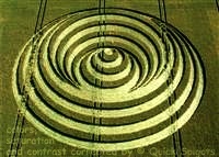
| 2011-03-20 | Mexiko | Crop circle / kruh v obilí Tequixquiac, nr. Santiago | oves | 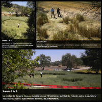 |
| 2011-01-29 | Indonézie | Crop circle / kruh v obilí Magelang, Tegalrejo | rýže | 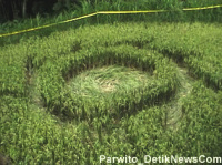 |
| 2011-01-25 | Indonézie | Crop circle / kruh v obilí Yogyakarta, Wanujoyo | rýže | 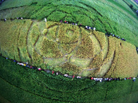 |
| 2011-01-23 | Indonézie | Crop circle / kruh v obilí Yogyakarta, Sleman | rýže | 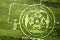 |
Delší úryvky, víc než jen Několik Vět, z domény cropcirclesonline.com včetně překladu do jakéhokoliv jazyka, by neměly být publikovány bez svolení autora
Týká se i fotografií s copyrightem ©cropcirclesonline.com ©quick spigots .
Kontaktujte cropcirclesonlinegmailcom nebo lightningsymbolshotmailcom
Citace samozřejmě povoleny. Prosíme uvést zdroj, odkaz. Díky. Děkujeme.